Ground Based Radar For Space Situational Awareness
Technology Roadmap Sections and Deliverables
This technology roadmap is identified as:
- 2GREAT - Ground Based Radar For Space Situational Awareness
Or as Ground-based Radar to Enable Awareness and Tracking (GREAT)
Space Situational Awareness and Tracking (SSA) is the operational concept to detect, identify, and track Resident Space Objects (RSOs), orbiting around the Earth. The SSA/T enterprise is comprised of ground-based and space-based sensors with a broad customer base. SSA originated from the need to track RSOs in orbit to support data analysis and collision avoidance of active satellite vehicles (SVs), inactive SVs, and orbital debris. As of 1 September 2023, the European Space Agency estimates about 8600 functioning SVs, over 1,036,500 objects greater than 1cm, and more than 11,000 tonnes of mass in orbit1.
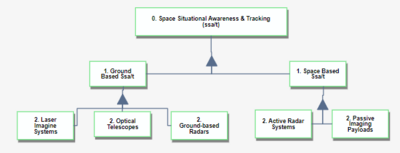
The figure below illustrates the levels within the SSA/T enterprise. Many systems comprise the architecture, each with technological challenges, advantages, and disadvantages.
Ground Based Radar For Space Situational Awareness and the SSA Enterprise
Roadmap Overview
SSA was initiated in the 1950s to support missile warnings of intercontinental ballistic missiles. The first of these radars was developed to identify and track missiles when they reach the apogee of their suborbital flight and begin their re-entry. In 1955, shortly after the sub-orbital radars began operation, the Soviet Union launched its first satellite, and a new space race began. With the growing concern about the need to track low earth orbit (LEO) satellites, most suborbital missile warning radars began to support detecting and tracking satellites.
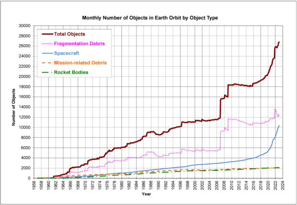
Today, over 26,000 objects over 10 cm are tracked by the United States SSA network, and countless more pieces of debris under 10 cm. This debris poses a risk to satellites in orbit, space stations, launch vehicles, and satellites transit through orbits.
Amount of Orbital Debris by Type, from NASA Quarterly "Orbital Debris" March 2022 Newsletter, Accessed 2 October 2023 https://orbitaldebris.jsc.nasa.gov/quarterly-news/pdfs/ODQNv27i1.pdf
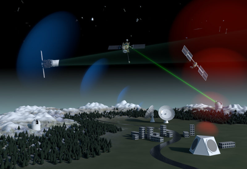
The Ground-based SSA network consists of multiple active and passive sensors. The most capable systems are ground-based radars. A ground-based SSA radar has varying subsystem architectures such as phased arrays, single arrays, monostatic, or bi-static systems. Each radar system varies in frequency and power based on the needs of that radar site. Many SSA systems are networked to support the shared object identification and tracking catalog.
Artist's impression of various SSA systems comprising a full SSA architecture. “Space Surveillance and Tracking - SST Segment.” Accessed October 1, 2023. https://www.esa.int/Safety_Security/Space_Surveillance_and_Tracking_-_SST_Segment.
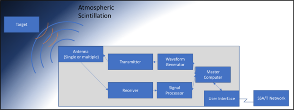
Broadly speaking, a ground-based radar consists of a radar transmitter and receiver, a master computer, and a user interface. The system emits a high-power waveform and then attempts to identify radar returns from the received noise. This process is not trivial. The system must transmit with enough power to overcome path loss, which reduces the range of a radar by Range4, and Atmospheric Scintillation in both directions. The return signal is often so faint that the main computer must use advanced signal processing and detection algorithms to find the return signal in the noise. The signal must then be tracked to collect its azimuth and elevation from the radar and the range and range rate. This data can then be used to identify and provide the object's location, as a two-line element, to cataloging agencies such as the United States Space Force.
Diagram showing Ground-Based Radar Overview
This Roadmap will explore what technology has driven the success of SSA radars, how to optimize the system further, and what innovative, potentially disruptive, technologies are on the horizon.
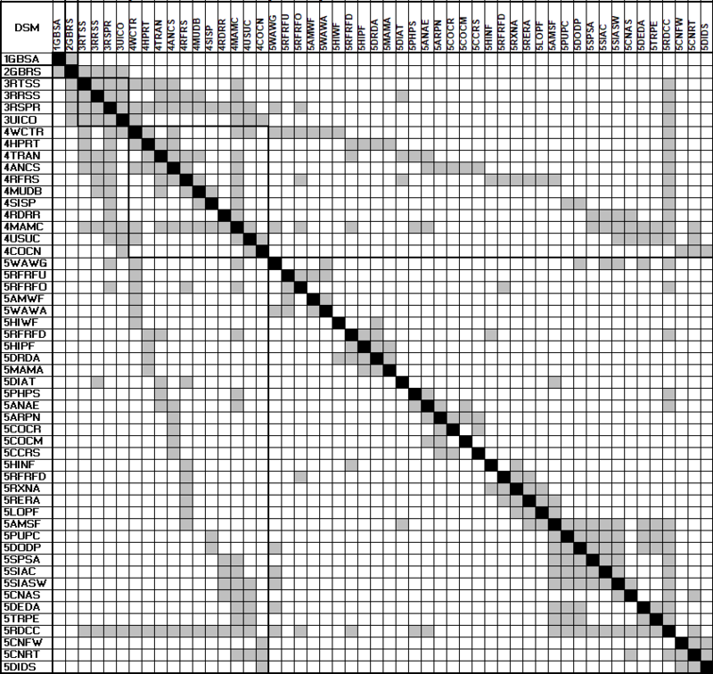
Design Structure Matrix (DSM) Allocation
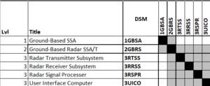
The DSM below provides a NxN mapping of the ground-based radar SSA system technologies. The DSM identifies the connective relationship between elements within the matrix (grey).
Roadmap Model using OPM
Figures of Merit
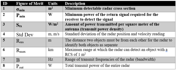
The table below shows the Figures of Merit (FOMs) that can be used to assess the improvement of Ground Based Radars for Space Situational Awareness. The key FOMs are indicated in bold.
The governing equations for the key FOMs are listed in the table below.
(insert table with equations)
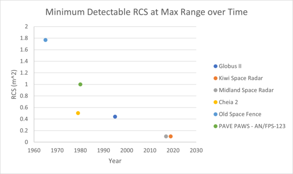
Short intro on min det rcs
Alignment with Company Strategic Drivers
Positioning of Company vs. Competition
Technical Model
Financial Model
List of Demonstrator Projects
Key Publications, Presentations and Patents
Technology Strategy Statement
References
[1] European Space Agency, Space Environment Statistics, Accessed 1 October 2023 https://www.esa.int/Space_Safety/Space_Debris/About_space_debris#:~:text=In%20more%20than%2060%20years,10%20cm%20in%20low%2DEarth
